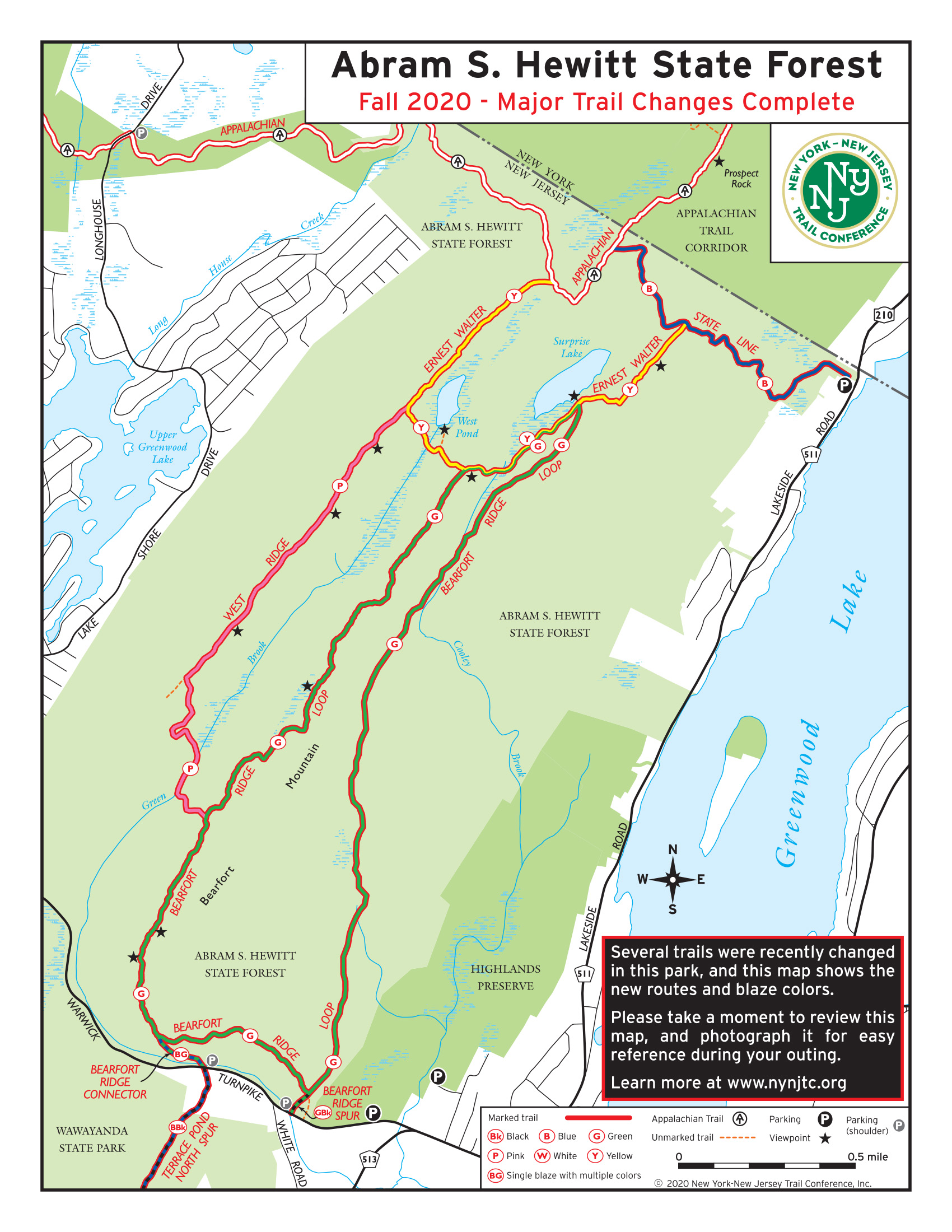
From the kiosk at the end of the parking area, bear left onto the blue-on-white-blazed State Line Trail, which follows a wide, rocky path up Bearfort Mountain. The ascent is moderate at first, and the trail soon levels off. With a private home visible ahead, the trail turns right and soon begins to climb more steeply. Take care to follow the blue-on-white blazes, as there are several side...
Hike Description:
From the kiosk at the end of the parking area, bear left onto the blue-on-white-blazed State Line Trail, which follows a wide, rocky path up Bearfort Mountain. The ascent is moderate at first, and the trail soon levels off. With a private home visible ahead, the trail turns right and soon begins to climb more steeply. Take care to follow the blue-on-white blazes, as there are several side trails that branch from the main route. Along the way, a switchback has been constructed to ease the grade.
In about three-quarters of a mile, you'll reach an intersection with the yellow-blazed Ernest Walter Trail, which begins on the left. Continue ahead on the blue-on-white-blazed State Line Trail, which continues across Bearfort Mountain, passing through an attractive forest of mountain laurel, hemlock and white pine. It climbs a little more, levels off, then traverses a series of ridges, with a number of climbs and descents.
About half a mile from the junction with the Ernest Walter Trail, the State Line Trail ends at a junction with the white-blazed Appalachian Trail (A.T.). Turn left onto the A.T. and immediately climb a rock outcrop, with views both east and west when there are no leaves on the trees. The A.T. heads south, soon reaching another seasonal viewpoint, then turns right and heads west.
In a third of a mile, after a steep descent from a ledge, the A.T. reaches a junction with the yellow-blazed Ernest Walter Trail. Turn left onto the Ernest Walter Trail, which climbs a little and traverses a whaleback rock. The trail continues south, crossing a series of open rock ledges.
After passing West Pond (visible through the trees below on the left), you’ll reach a junction with the pink-blazed West Ridge Trail. Here, the Ernest Walter Trail turns left, but you should continue ahead along the ridge, now following the West Ridge Trail.
The West Ridge Trail traverses more open rock ledges, then climbs gently on a moss-covered footpath through the woods. Soon, it emerges onto another open rock ledge, with limited north- and east-facing views. The trail continues to head south, with some gentle ups and downs, and passes two more limited east-facing viewpoints. The final viewpoint is at elevation 1,437 feet - the highest elevation in Abram S. Hewitt State Forest, and nearly 800 vertical feet above the trailhead.
Beyond this viewpoint, the West Ridge Trail begins to descend. Along the way, it reaches a T-intersection with a woods road, where it turns left. At the base of the descent, the West Ridge Trail turns right and parallels the Green Brook for about 750 feet. It then turns left, crosses the brook on huge rocks, and climbs (steeply in places) to a junction with the green-blazed Bearfort Ridge Loop.
Turn left onto the Bearfort Ridge Loop, which heads north through a forest of pitch pines and hemlocks at an elevation of about 1,300 feet. The trail traverses an open rock outcrop with a row of large glacial erratics, and it descends to cross a wet area. After about half a mile of walking along the ridge, the Bearfort Ridge Loop comes out on a rock ledge overlooking a wetland to the west. Here, a narrow wedge of the bedrock has split away from the main ledge, forming a deep crevice. This is a good place to take a break.
When you're ready to continue, proceed north along the trail, which climbs to a rock outcrop with a huge boulder. After traversing a whaleback rock, the trail descends steadily through hemlocks and laurels, crossing an intermittent stream at the base of the descent. It then climbs over jumbled rocks to a rock outcrop studded with pitch pines, which offers a limited east-facing view when there are no leaves on the trees.
The trail continues across more rock outcrops, with limited views both to the west and to the east. It then descends gently and levels off. Finally, it climbs to another outcrop -- marked by several cedar trees -- with a panoramic view. Sterling Forest and the Wyanokies can be seen to the east, and if there are no leaves on the trees, you may be able to see Surprise Lake to the north. An arm of the Monksville Reservoir is visible ahead, and on a clear day you can see the tops of New York City skyscrapers in the distance.
Here, the green-blazed Bearfort Ridge Loop reaches a junction with the yellow-blazed Ernest Walter Trail. Bear right and follow the joint green-and-yellow blazed trail as it heads downhill through a rocky area, steeply in places, and soon crosses Cooley Brook, the outlet of Surprise Lake, on rocks. The trail continues through a dense rhododendron grove, with the thick rhododendrons forming a canopy over the trail in places. In half a mile, the green-blazed Bearfort Ridge Loop turns sharply right. Continue ahead on the yellow-blazed Ernest Walter Trail for about 100 feet to an open area which overlooks Surprise Lake - a pristine, spring-fed pond. This is another good spot to take a break.
When you’re ready to continue, follow the yellow-blazed Ernest Walter Trail, which heads east. After crossing the outlet of a wetland, the trail climbs to a series of rock outcrops studded with pitch pines, with limited views over Greenwood Lake to the east. Continue ahead until, after traversing a wooded area, you reach the highest outcrop. From here, there is a panoramic view over the six-mile-long lake, 650 vertical feet below, with the hills of Sterling Forest in the background.
The Ernest Walter Trail now descends steadily, with more views over the lake, until it ends at a junction with the blue-on-white-blazed State Line Trail. Turn right onto the State Line Trail, now retracing your steps, and follow the trail as it descends steadily to the parking area on Lakeside Road where the hike began.
Publication: Submitted by Daniel Chazin on 09/25/2020

This loop hike traverses the Bearfort Ridge, with its unusual puddingstone conglomerate rock, goes through a rhododendron tunnel, passes Surprise Lake, and reaches a panoramic viewpoint over Greenwood Lake
41.18575, -74.33126
Passaic Co., NJ
7 mi
6 hrs

Avenza App Map: Northern New Jersey Highlands 152
Directions to Trailhead :
Take I-287 to Exit 57 and continue on Skyline Drive to its western end at Greenwood Lake Turnpike (County Route 511) in Ringwood. Turn right and proceed for 8.1 miles to an intersection with Lakeside Road. Turn right and follow Lakeside Road (still designated County Route 511) for 2.4 miles to the Greenwood Lake Marina, just south of the New Jersey-New York boundary. Turn left and park on the left side of the dirt access road, west of Lakeside Road (only limited parking is available). Do not, under any circumstances, park on the private property of the Greenwood Lake Marina, on the east side of Lakeside Road.
TRAIN TRANSPORT :
Not availableBUS TRANSPORT :
Take the #197 NJ Transit bus from the Port Authority Bus Terminal in Manhattan. This bus runs only about every two hours on weekends and non-rush hours, so check the schedule carefully
 Give $10 to support trails.
 December 31, 1969
 19:00 pm
Trip Reports
rate experience May 03, 2021
Significant tree down across trail
During recent weekend hike of newly blazed Pink trail, noticed large and tall dead pine tree (with blaze) has fallen across trail immediately after crossing Green Brook forcing a detour off trail.
May 03, 2021
Great work on the newly blazed trail
We took this trail up from the Stateline trailhead completing Blue to the AT to Yellow to Pink to Green to Blue. The trail crew did a great job re-blazing an historically confusing trail network. Thank you.
December 14, 2020
Hiking Abram Hewitt Forest
Lovely. Not very travelled since it is somewhat new. We enjoyed it.