This hike follows the northern section of the Blue Mountain Loop Trail, blazed with a blue dot on white. This trail, constructed by the park in the summer of 2015, incorporates a number of pre-existing trails.
...
This hike follows the northern section of the Blue Mountain Loop Trail, blazed with a blue dot on white. This trail, constructed by the park in the summer of 2015, incorporates a number of pre-existing trails.
 Head northeast on the blue-dot-on-white-blazed Blue Mountain Loop Trail, which parallels the Big Flat Brook. In 0.2 mile, you'll reach the start of the yellow-blazed Tinsley Trail. Turn right onto the Tinsley Trail, which climbs on switchbacks, crosses a paved road, and continues on a gated woods road. Several marked trails formerly maintained by the New Jersey State School of Conservation branch off to the left, and one of these trails (the Purple Finch Trail) is co-aligned with the Tinsley Trail for some distance.
After descending to a wetland, the Tinsley Trail begins a gradual climb. About half a mile from its start, you’ll reach a fork, where you should bear right to continue along the Tinsley Trail. The trail now levels off, but it soon resumes its climb.
At the next junction, turn left, leaving the Tinsley Trail, and follow the blue-dot-on-white blazes of the Blue Mountain Loop Trail, which descends on a rocky footpath. You will be following the Blue Mountain Loop Trail for the remainder of the hike.
In a third of a mile, you’ll reach an open area with a locked cabin and an adjacent picnic table. Continue ahead on the Blue Mountain Trail, which follows a level woods road. In about half a mile, after crossing several branches of a stream, follow the Blue Mountain Loop Trail as it turns right, leaving the woods road.
The Blue Mountain Loop Trail climbs on a footpath, paralleling a stream on the left. After crossing the stream on rocks, the trail levels off. Soon, it crosses another stream and continues through a dense understory of ferns. It then climbs a little more to cross the paved Sunrise Mountain Road. The climb steepens on the other side of the road, and, in a short distance, the trail reaches a panoramic west-facing viewpoint from an open rock ledge, with several pine trees. This is a good spot to take a break.
 After climbing a little more, you’ll come to another junction. Here, the Cartwright Trail (as well as a side trail with black/blue blazes) begins, but you should turn left, continuing to follow the blue-dot-on-white blazes of the Blue Mountain Loop Trail. Soon, you’ll come to another west-facing viewpoint from an open rock ledge.
In another quarter mile, follow the Blue Mountain Trail as it turns left onto an eroded woods road. After descending some more on this road, the Blue Mountain Loop Trail turns right onto an intersecting woods road. Just beyond, the grey-on-white-blazed Howell Trail begins on the left.
The Blue Mountain Loop Trail now descends gently. In about a mile, it crosses a few short wooden bridges and then a longer bridge over the Big Flat Brook. It continues to descend a little, but after crossing a stream on rocks, the trail begins to climb. After leveling off, the trail descends gradually, then crosses a wet area on puncheons. Soon, it reaches a grassy woods road -– the route of the blue-blazed Parker Trail.
Turn left onto the road, which descends gradually. In about half a mile, follow the blue-dot-on-whte blazes as they turn left, leaving the road, and descend on a footpath.
Soon, you’ll reach the paved Crigger Road, with a piped spring on the opposite side of the road. Turn left onto the paved road, continuing to follow the blue-on-white blazes of the Blue Mountain Loop Trail. The trail crosses the Big Flat Brook on the road bridge, then turns right, leaving the paved road, and continues on a footpath.
For the next two miles, the trail proceeds through a hemlock forest, closely paralleling the cascading Big Flat Brook. This is the most interesting and beautiful portion of the hike, and you’ll want to take your time to enjoy this trail section.
After about 1.2 miles of pleasant walking along the brook, you’ll traverse an open grassy area, with a fenced-in area on the left. A short distance beyond, the Blue Mountain Loop Trail turns right and crosses an impressive wooden footbridge over the outlet of Lake Wapalanne. Just beyond, you’ll pass the ruins of a stone fireplace, and the Brown Creeper Trail joins from the left.
Soon, the Blue Mountain Trail turns left, away from the brook. With a parking area and buildings of the former New Jersey School of Conservation visible ahead, the Blue Mountain Trail turns right and continues high above the brook. In a short distance, joined by the Orange Wood Lily Trail, it descends to the level of the brook, which it follows around a bend.
A short distance beyond, the yellow-blazed Tinsley Trail begins on the left. Continue ahead on the Blue Mountain Loop Trail until you reach the parking area where the hike began.
Publication: Submitted by Daniel Chazin on 07/15/2016 updated/verified on 06/19/2019

This hike loops around the northern section of Stokes State Forest, climbing to two panoramic viewpoints and paralleling the scenic Big Flat Brook.
This hike follows the northern section of the Blue Mountain Loop Trail, blazed with a blue dot on white. This trail, constructed by the park in the summer of 2015, incorporates a number of pre-existing trails.
...
Whether you are going for a day hike or backpacking overnight, it is good practice to carry what we call The Hiking Essentials. These essentials will help you enjoy your outing more and will provide basic safety gear if needed. There may also be more essentials, depending on the season and your needs.
Hiking Shoes or Boots
Water - Two quarts per person is recommended in every season. Keep in mind that fluid loss is heightened in winter as well as summer. Don't put yourself in the position of having to end your hike early because you have run out of water.
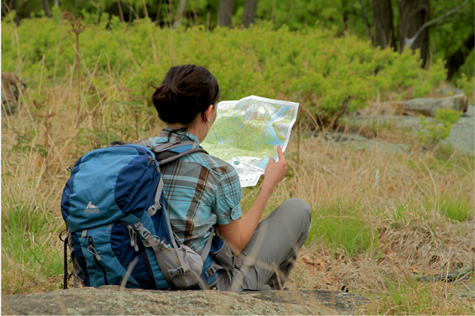
Map - Know where you are and where you are going. Many of our hiking areas feature interconnecting network of trails. Use a waterproof/tear-resistant Tyvek Trail Conference map if available or enclose your map in a Ziplock plastic bag. If you have a mobile device, download Avenza’s free PDF Maps app and grab some GPS-enhanced Trail Conference maps (a backup Tyvek or paper version of the map is good to have just in case your batteries die or you don't have service). Check out some map-reading basics here.
Food - Snacks/lunch will keep you going as you burn energy walking or climbing. Nuts, seeds, and chocolate are favorites on the trail.
Sunscreen and insect repellent
Rain Gear and Extra Clothing - Rain happens. So does cold. Be prepared for changing weather. Avoid cotton--it traps water against your skin and is slow to dry. If you are wearing wet cotton and must return to your starting point, you risk getting chills that may lead to a dangerous hypothermia. Choose synthetic shirts, sweaters and/or vests and dress in layers for easy on and off.
Compass - A simple compass is all you need to orient you and your map to magnetic north.
Light - A flashlight or small, lightweight headlamp will be welcome gear if you find yourself still on the trail when darkness falls. Check the batteries before you start out and have extras in your pack.
First Aid Kit - Keep it simple, compact, and weatherproof. Know how to use the basic components.
Firestarter and Matches - In an emergency, you may need to keep yourself or someone else warm until help arrives. A firestarter (this could be as simple as leftover birthday candles that are kept inside a waterproof container) and matches (again, make sure to keep them in a waterproof container) could save a life.
Knife or Multi-tool - You may need to cut a piece of moleskin to put over a blister, repair a piece of broken equipment, or solve some other unexpected problem.
Emergency Numbers - Know the emergency numbers for the area you're going to and realize that in many locations--especially mountainous ones, your phone will not get reception.
Common Sense - Pay attention to your environment, your energy, and the condition of your companions. Has the weather turned rainy? Is daylight fading? Did you drink all your water? Did your companion fail to bring rain gear? Are you getting tired? Keep in mind that until you turn around you are (typically) only half-way to completing your hike--you must still get back to where you started from! (Exceptions are loop hikes.)
Check the weather forecast before you head out. Know the rules and regulations of the area.
Travel and Camp on Durable Surfaces
Be Considerate of Other Visitors
The Trail Conference is a 2015 Leave No Trace partner.
(c) Leave No Trace Center for Outdoor Ethics: www.LNT.org.
Take I-80 to Exit 34B and continue north on NJ 15 for about 17 miles. When NJ 15 ends, continue ahead on US 206 North for 8.6 miles and turn right onto Flatbrook Road. In 1.0 mile, turn sharply right to continue on Flatbrook Road. Continue for another 1.8 miles and turn right onto Skellenger Road. Proceed ahead for another 0.4 mile. After crossing a stone-faced bridge over the Big Flat Brook, the road ahead is gated. Park along the shoulder of the road.
 Support the trails with a donation!